Last of the Summer Wine the Big Sausage Search
Click the image below to see the video
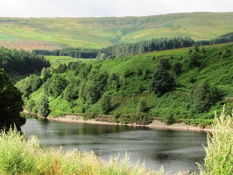
Holmfirth – Ramsden Reservoir to Hade Edge round
West Yorkshire is a metropolitan county within the Yorkshire and the Humber region of England and came into existence as a metropolitan county in 1974 after the passage of the Local Government Act 1972. The county is landlocked and consists of five boroughs the City of Bradford, Calderdale, Kirklees, City of Leeds and City of Wakefield and shares borders with the counties of Derbyshire to the south, Greater Manchester to the south-west, Lancashire to the north-west, South Yorkshire to the south-east and North Yorkshire to the north and east. West Yorkshire has the most built up and biggest urban area within the historic county boundaries of Yorkshire and lies almost entirely on rocks of carboniferous age which form the southern Pennine fringes in the west and the Yorkshire coalfield further eastwards. In the very east of the county there are younger deposits of magnesian limestone. The Bradford and Calderdale areas are dominated by the eastern slopes of the Pennines producing many steep-sided valleys with a network of roads, canals and railways. This large industrial and urban area creates views of a wonderful mixture of open countryside, settlements and demanding hills. The Yorkshire coalfield is a rolling landscape of hills, escarpments and broad valleys with many converted or derelict mine buildings and recently landscaped former spoil heaps. The magnesian limestone belt to the east of Leeds and Wakefield is an elevated ridge with smooth rolling scenery and dry valleys dotted with many country houses and estates with parkland, estate woodlands, plantations and game coverts. The River Aire and the River Calder drain the area, flowing from west to east. The River Aire is a major river flowing for 71 miles rising at Malham Tarn and after passing through West Yorkshire it enters the River Ouse at Airmyn in the East Riding of Yorkshire. Part of the river is canalised and is known as the Aire and Calder Navigation. The River Calder a tributary of the River Aire rises on the slopes of the Pennines at Heald Moor near Todmorden in Calderdale and flows for 45 miles before entering the River Aire at Castleford the confluence of the Aire and Calder.
The Peak District is made up of two areas The White Peak which is a limestone plateau of green fields with rolling hills and many dales and The Dark Peak (or High Peak) which is a series of higher, wilder and boggier grit stone moorlands. The Peak District is also known as the Derbyshire Peak District and also covers areas of Greater Manchester, Staffordshire, Cheshire, West Yorkshire and South Yorkshire. Although there are no prominent boundaries the central and most rural area of the Peaks lie within the Peak District National Park. The National Park covers 555 square miles of Derbyshire, Cheshire, Greater Manchester and South and West Yorkshire and 12% of the park is owned by the National Trust a charity which aims to conserve historic and natural landscapes and does not receive government funding. The Peak District National Park Authority provides public facilities such as car parks, public toilets, visitor centres and also maintains the rural nature of the park although most of the land is still owned by the traditional landlords.
Holmfirth attracts thousands of visitors and fans of the television series “Last of the Summer Wine” every year to visit Sid’s Cafe, Nora Batty’s home and Steps, the Wrinkled Stocking Tea Room and the Summer Wine Exhibition. It is the longest running comedy programme in Britain and the longest running sitcom in the world. The cast has changed many times over the years with the original trio being Bill Owen as scruffy Compo, Peter Sallis as deep thinking Cleg and Michael Bates as snobbish Blamire and they always got themselves involved in daredevil stunts and boyish pranks. The late Bill Owen was heavily involved in the creation and design of The Summer Wine Exhibition and was keen to provide an interesting and memorable feature for visitors and was officially opened by Compo on Easter Saturday 1996 the 25th anniversary of the programme. The Wrinkled Stocking Tea Room named after the famous stockings worn by Nora Batty who is also a star of the series “Last of the Summer Wine” and appropriately named for it is situated next door to the TV homes of Nora and previously Compo. The Picturedrome Cinema is also popular and there are a wide range of shops, restaurants, wine bars, pubs and a variety of take-away to suit all pallets. There is a vintage market on Wednesdays, a general market on Thursdays, craft and food market on Saturdays, a farmers market every third Sunday and various special markets throughout the year. Holmfirth with its wonderful scenery across the Holme Valley is also popular with walkers and wildlife enthusiasts. Watch out for the wildlife beside the river you never know what you may see. There are many walks and cycle routes so why not head out for the hills, with your camera, where you will find peace, fresh air and panoramic views all year round. The most popular walks are Digley Reservoir, Blackmoorfoot Reservoir, Ramsden Reservoir, Holme Valley Riverside Way, Holme Valley Circular Walk, Holme Moss View Point and Holmbridge and Holme Walk.
The Kirklees Way is a 72 mile way marked footpath. It opened in 1990 and includes the Upper Colne Valley, Spen Valley and Holme Valley.
The Holme Valley Circular Walk is a 24 mile walk through the Holme Valley taking in a wide variety of scenery from quiet villages to rolling fields and wooded valleys. The walk starts from Berry Brow Railway Station near Huddersfield and heads south to Honley, Netherthong and Holmfirth. It then passes around a series of reservoirs surrounding Holmbridge then continues to Hade Edge, Hepworth and Thurstonland before returning to Berry Brow. There are many vantage points along the route providing beautiful panoramic views, including the historic Castle Hill an Iron Age Hill Fort.
Hade Edge is a small village surrounded by stunning countryside and overlooks Boshaw Whams Reservoir. The Huddersfield Sailing Club is situated at the far side of the reservoir and they hold annual sailing competitions. The village houses a Junior and Infant School, a Pre-School, a Methodist Church, a butcher shop (The Big Sausage) who do fantastic award winning pies and a pub the Bay Horse. There was once a co-op and a fish and chip shop, both closed in the 1950, and a grocery store and post office which closed in 1989.
Holme Styes Reservoir, frequently used in episodes of Last of the Summer Wine, is a very pretty little reservoir on the edge of the woods south of Holmfirth. There is a lovely walk up through the woods to Hades an old abandoned settlement.
The Walk
We park in Ramsden Reservoir car park and make our way to the picnic area and turn right uphill past a bench then bear right between two walls into some trees. We follow the wall on our right with a stream on our left. We soon cross the stream and when we come to a stile and a wall we do not cross but turn right on the Kirklees Way. We keep following the track uphill turning left at the sign post for Ramsden Road until we meet the road. We now turn right and follow the minor road for approx 1.75 miles until we come to a cross roads. We cross over the road and turn immediate left down a track. We head forwards downhill passing a farm and a building on our right then a little further on we turn right over the stile with a yellow marker. At the little road we turn right then left at the farm. We walk by the side of the farm following the footpath sign then head forwards to meet a road. We cross straight over and take the footpath to the left through the fields until we meet another road. We turn right slightly downhill then at the junction we turn left onto Upper House Road and head forwards. We are now at Strines Moor. After walking round the bend to the right we walk to the end of the houses and turn left at the footpath sign going uphill to a house. We keep heading forward until we meet the road. We turn left slightly downhill with Boshaw Whams Reservoir on our left to the t-junction then turn right past the Brindon Addy butcher shop (The Big Sausage) towards the Bay Horse pub. We turn left opposite the pub onto Bent Lane then straight forwards at the sign for Standbank Farm. We pass a seat and then walk through the middle of the farm following the footpath sign. We go through a gate, turn left and head forwards to the left of the wall going downhill to meet the road. We can see Holme Styes Reservoir down below on the right. At the road we turn right downhill then at the bend we turn left onto Clough Foot Lane and follow the track. The track splits into two we take the right fork down to Holme Styes Reservoir. At the gate we turn right to cross the bridge at the end of the reservoir. Immediately after the bridge we turn left, no sign post, uphill through the trees alongside Reynard Clough. At the top we turn right and head forwards to meet a track we bear left and keep following the track going over a stile next to a gate then straight over at the cross roads of tracks until we meet the road. We turn left then immediate right over a field downhill following the wall on our right. At the bottom we cross over a little stream and head uphill on the track to the left of the trees. We keep following the track through the fields going through a small gate at the side of a big gate and ignoring two paths on the right and one on the left and head downhill until we come to the stile and the wall at the start of our walk. We go over the stile and bear right retracing our steps back to Ramsden Reservoir.
Terrain
This is an easy walk using footpaths and tracks, some quite stony, on the Kirklees Way and Holm Valley Circular Walk. There are fields with gates and stiles, some minor road walking and some gradual gradients.
Elevation: Approx lowest point 253m (830ft) approx highest point 436m (1430ft)
Distance and Start Point
Approx 7.5 miles allow 3 hours using OS Explorer Map OL1, The Peak District Dark Peak Area.
Start Point: Ramsden Reservoir free car park.
Location
Ramsden Reservoir is south west of Holmfirth in the District of Kirklees, West Yorkshire.
Directions and Parking
From the M1 coming from the north take junction 39 and take the A636 to Denby Dale then turn right onto the A635 and follow the A635 into Holmfirth. In Holmfirth at the main traffic lights turn left onto the A6024 to Holmbridge. Take the little road on the left just over the bridge then right uphill for about a mile and Ramsden Reservoir car park is on the left.
From the M1 coming from the south take junction 37 and follow the A628 at the second roundabout turn right for Huddersfield then turn left onto the A635 and follow the A635 into Holmfirth. In Holmfirth the directions are as above.
Parking: Ramsden Reservoir free car park.
Toilets and Refreshments
There are no public toilets the nearest ones are at Holmfirth. For refreshments there is a butcher and a pub the Bay Horse at Hade Edge. There are ample shops, cafes, take-away, pubs and restaurants in Holmfirth. There is a picnic area at Ramsden Reservoir.