Click the image below to see the video
Fordingbridge Woodgreen Hale Godshill round
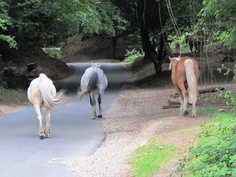
The New Forest and its National Park is a wonderful and beautiful place situated in Hampshire down in Southern England. The New Forest National Park was created in March 2005 after six years of consultations. A national park authority was established in April 2005 and gained full statutory powers in April 2006. The park covers 140,000 acres and includes many existing Sites of Special Scientific Interest (SSSI) and lies mainly in south-west Hampshire from east of the Avon Valley to Southampton Water and from the Solent coast to the edge of the Wiltshire Chalk Downs. The Forest is a living and working place with so many thatched cottages, hidden gems and secrets making it a haven for walkers, cyclists, horse riders and tourists. To enable you to enjoy the forest to its full potential is to leave the car and get out there and explore. There are many circular routes, which can be found in the tourist information places, with picnic areas and toilet facilities. There are also guided walks where experts will tell you about the forest, its history and wildlife etc. There is also the New Forest Tour which is an open top bus taking you on many routes round the forest and villages and you can hop on and off where ever you like. This is fun for everyone and ideal for people who cannot walk far or are disabled. The New Forest Museum and Visitors Centre in Lyndhurst is the best place for any information and advice. The main attraction of the New Forest is the wild ponies that roam free but are actually owned by New Forest Commoners. There are approximately 3,000 ponies and have lived here for about 2000 years. The foals are born in the spring and summer and they are a delight to see. In the summer and autumn each year Pony drifts are held so that the commoners can sell their stock and the job of tail clipping and veterinary checks can be done at the same time.
Fordingbridge in the New Forest district of Hampshire is a town on the River Avon near to the Dorset and Wiltshire borders on the edge of the New Forest. Fordingbridge was once an industrial and commercial centre with many trades but mainly known for its smuggling. The former market town also had a railway station which closed in 1964 and the Avon Valley Path passes through the centre. There are plenty of shops, cafes and pubs here and also an information centre and a museum.
Woodgreen is in the valley of the River Avon and is a small attractive village with a common where there are lots of forest ponies, a pub The Horse and Groom and a new community shop. One mile to the south are the earthwork remains of Godshill Castle which was a ring and bailey castle probably built in 1148.
Hale is a very small village with part of its boundary being the River Avon and another part the Hampshire/Wiltshire border. The village centre is Hatchet Green which is an SSSI and Conservation Area. St. Mary’s Church is an Anglican church and has been designated by English Heritage as a Grade Two listed building. Hale Park House is a large building which was rebuilt about 1715 and has been added to over the years.
Godshill is a small scattered working forest village retaining strong links with Commoning traditions therefore there are plenty of forest ponies around. There is a pub The Fighting Cocks and the Caravan holiday centre of Sandy Balls.
The Walk
We start from the car park at the back of The Crown and turn left and walk along the main street until we come to a t-junction here we turn left and walk past Tesco on the right. At the next t-junction by the post office we turn left and then follow the road round to the right until we come to Pennys Lane. We turn right into Pennys Lane and at the bend in the road we take the footpath on the left, the Avon Valley Path, then we carry on forward until we reach a track here we turn right which takes us to the main road (A338). We turn right and walk past the Tudor Rose Inn, cross the road, then opposite the Sun Valley restaurant we take the footpath on the left and walk past the buildings on the left then immediately go over the iron footbridge on the left over the River Avon. Then through the gate, we are now in the New Forest National Park. We head forward through the wetlands, on the Avon Valley Path, going over some more footbridges and fields. We pass some buildings on the left and greenhouses on the right carry on forward until the track splits we take the left fork which takes us to the road where we turn left. We follow the road, stopping to take a look at the view at Castle Hill view point, until we come to a t-junction and turn left and then follow this road down into Woodgreen. We turn right at the triangle past the bus stop and then turn right just after the Horse and Groom which takes us to Woodgreen Common. Before we turn right at the pub, optional, we walk straight ahead to have a look at the new community shop. We walk round the common to take a look at the Forest Ponies with their foals and a Master Thatcher. We then walk back and take the footpath next to a thatched barn, sign posted Avon Valley Path, we walk forward and follow the path to the left then we go through a gate then over a field to another gate which brings us to a road. We turn right onto the road then left down Moot Lane towards Downton we head forwards on the road until we see a footbridge on the left and a footpath on the right to St. Marys Church. We take a look at the bridge over the River Avon first before heading up to St. Marys Church. We follow the track past the church and then Hale House on the right and then take the footpath at the side of Hale House driveway. At the road we turn right. We follow the road, passing a house with 1923 on the wall, then just after the bend we take the small no through road on the left in front of some buildings, this is Hale. We pass the old rectory and Hemmick Court on the right. When we get to the end of the road there are three paths we take the one on the right we head forward through the trees and Rhododendrons to a crossroads and then turn right onto the bridleway we go under a pylon and carry on forward until we come to a high fence in front of us. We turn left then at the t-junction we turn right onto a track then almost immediately we turn left over a stile and head forward towards the trees, we carry on forward to the road and turn left. When the road bends sharply to the left we head forward through the barrier. We then turn right opposite the house and follow the footpath which heads downhill to a footbridge then we make our way up the hill on the other side until we come to the road. We turn right and follow the road to Godshill passing the Fighting Cocks pub then over a cattle grid where we now leave the New Forest National Park. When we arrive at Sandy Balls caravan site we turn right into the site entrance then immediately left and follow the footpath through the lodges. At the residential properties we carry on forward past the homes then over a stile, through the trees until we come to another stile. We go over the stile into a field and head over the field to the left hand corner and onto the road. We turn right and follow the road crossing the A338 then over the bridge into Fordingbridge.
Terrain
This is an easy to hard walk with some steep inclines and declines.
Distance
Approx 10.5 miles using OS map OL22
Location
Fordingbridge in the New Forest
Directions
Fordingbridge is on the A338 between Salisbury and Ringwood
Toilets and Refreshments
There is a flexiloo in Fordingbridge just near the post office. For refreshments there are plenty of shops and pubs in Fordingbridge and the Tudor Rose Inn on the A338. In Woodgreen there is a community shop and the Horse and Groom pub. In Godshill there is a pub The Fighting Cocks and there is a shop at Sandy Balls Holiday Centre